|
|
Altrincham Electric Railway Preservation Society |
| Home Coaches Excursions Lectures Membership MSJ&AR Photo Gallery Site Map |
From 1992 to the present; the sections are:-
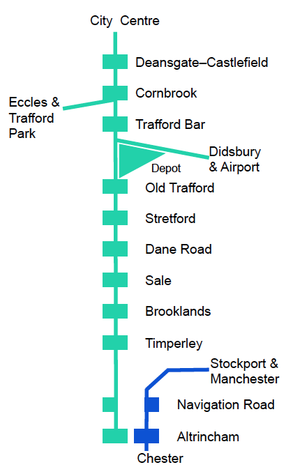
Introduction Metrolink in Central Manchester Deansgate–Castlefield CLC Viaduct and Cornbrook stop Trafford Bar Metrolink Trafford Depot Old Trafford Timperley to Altrincham
In 1980 Manchester still had separate north and south mainline railway networks. Little expansion of rail traffic was expected and most Manchester services were to be concentrated at Piccadilly Station.
Some lines in Greater Manchester had only/mainly local services and required increasing levels of subsidy plus considerable capital expenditure for renewals. The original Metrolink six line scheme came from several studies into light rail alternatives. Lines to Altrincham, Bury, Rochdale via Oldham, Hadfield/Glossop and Marple/Rose Hill would be converted. Reopening the old Midland route from Trafford Bar to East Didsbury would be the sixth line. New street running track would provide cross city connections and ready access to the city centre.
The network was to be built in stages and the first stage had to be able to stand on its own. Thus the Altrincham Line, Bury Line, and City Centre street running tracks were phase one of Metrolink.
Obtaining funding was not easy. In 1987 the Government required a Design, Build, Operate and Maintain (DBOM) project with investment of some private sector capital before authorising the scheme. Available funding only allowed the minimum upgrades to be made.
Phase 2 was another DBOM project; the Eccles Line from Cornbrook, on the Altrincham line, through Salford Quays and on to Eccles.
Phase 3 was to have been a further DBOM project, however increasing costs and uncertainty of final cost lead to the Government cancelling the funding on 20 July 2004. The reaction in Greater Manchester was of anger and fury.
GMPTE launched the Get Our Metrolink Back On Track Campaign on 12 August 2004. By that date there had been over one hundred articles in the local papers and on their web sites.
Phase 3a funding was agreed on 6 July 2006. After Congestion Charging proposals were rejected, the TIF bid was abandoned in December 2008. A Greater Manchester Transport Fund was agreed on 13 May 2009, this included funding for phase 3b. The opening of a second cross city route via Exchange Square in February 2017 completed phase 3.
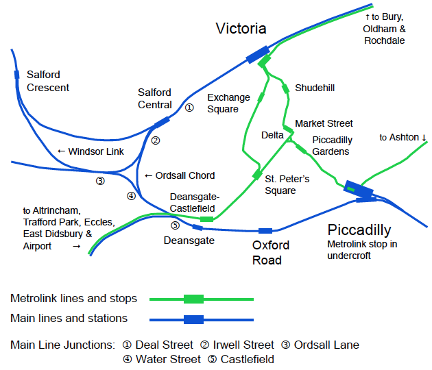
| City Centre Railways and Metrolink |
 |
| Deal Street, the road, has been redeveloped out of existence. It ran through the arch with a higher parapet wall, about 330 metres towards Victoria from Salford Central; this arch now contains part of a bathroom and tiles showroom. |
Light Rail systems can have sharper curves and steeper gradients than main line railways. These characteristics enable them to fit into street layouts, with shared and/or dedicated space. Metrolink has a minimum curve radius of 25 metres and a maximum gradient of 6.5% or about one in 15.39.
Metrolink’s original (phase 1) city centre street level routes are from the delta to Victoria, Piccadilly and Deansgate–Castlefield. They are outbound away from and inbound towards the delta. Deansgate–Castlefield to Victoria is 3.1km, this is now referred to as the first cross city route (1CC). The branch to Piccadilly is 0.7km; its phase 3 extension goes to Ashton.
Phase 3 requires a second cross city route (2CC) from Deansgate–Castlefield to Victoria via Exchange Square. This is northbound towards Victoria and southbound towards Deansgate–Castlefield.
From Deansgate–Castlefield first and second cross city routes share the Metrolink viaduct, alongside Manchester Central. From there to St. Peter’s Square Metrolink tracks along Lower Mosley Street have been re-built
Inbound, the 1CC & 2CC points are south of Windmill Street, which is crossed as interlaced tracks. On the reserved way, 2CC northbound track is adjacent to the Midland Hotel, 1CC inbound track diverges onto the former reserved way outbound track space. North of Windmill Street the outbound line moves off the reserved way and shares road space with traffic.
St. Peter’s Square is a new double island platform stop; located at the Princess Street end of the enlarged square. This allows cross–platform interchange between first and second cross city routes in both directions.
After this stop, 2CC turns into Princess Street, runs alongside the Town Hall and Albert Square. It then turns into and runs along Cross Street, continuing along Corporation Street, with an island platform stop at Exchange Square, and onto Victoria Station.
The square has been enlarged and re–modelled, as part of Manchester City Council’s Civic Quarter regeneration. It now includes the space between Princess Street and Peter/Oxford Streets in a north–east/south–west (ne/sw) direction also the Town Hall & Central Library buildings to the north–west to the new 1 & 2 St. Peter’s Square office blocks to the south–east.
The Cenotaph has been relocated near to the narrow south–eastern end of the Town Hall. A reinforced concrete slab covers the crypt of St. Peter’s Church. Also the cross marking this crypt has been re–positioned. Apart from Metrolink, the expanded St. Peter’s Square is traffic free. General traffic in a ne/sw direction and the sw/ne bus routes have been removed.
Metrolink rises from street level using the purpose built viaduct alongside Manchester Central (formerly G–Mex). It crosses the bow–string bridge over Great Bridgewater Street. After passing the emergency trailing crossover, another bridge over Trafford Street takes it onto the CLC viaduct.
Known as G–Mex when first built; it had staggered platforms, outbound to the east and inbound to the west of the footpath from Deansgate rail station. This was where trams changed from street to segregated running under the original signalling system.
The stop was renamed Deansgate–Castlefield in September 2010.
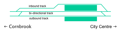 |
| Platform and track layout, from June 2015 |
Funded in part by a European Regional Development Fund (ERDF) grant, the stop has been completely rebuilt and expanded to a high standard. This improves Metrolink’s capacity for the increased number of services that will operate with the second city crossing.
The new island platform has a ramp at the city centre end and steps at the other end. Inbound trams use the northern face, with the centre face able to be used in both directions.
The outbound platform has steps at both ends. To give step free platform access, a path with ramps in both directions replaced the former level path against the viaduct wall. A new wall with a translucent vertical extension has been built on its own foundation just inside the original parapet.
A left hand facing turnout, just west of the old inbound platform position, takes the new inbound line through the former platform site. Associated with this is a crossover which enables a length the old inbound track to become bi–directional. This layout, shown in the diagram, is now controlled by TMS.
A new stairway from Whitworth Street West pavement to the stop has replaced the former stairway at the Albion Street end.
The footbridge from Deansgate rail station, opened 1984, has been refurbished. Its former ‘tubular’ covering had deteriorated becoming considerably darker and broken in places. Within the existing skeletal structure, new transparent side walls have been provided.
The former brick stairway at the Deansgate end of Whitworth Street West has been demolished. A new lift and lightweight stair arrangement set in front of a dramatic ‘green wall’ are now in use.
The CLC Viaduct from Manchester Central Station to Cornbrook Junction was originally built as a two track viaduct then later widened to carry five tracks. Central Station closed in 1969 and the viaduct was unused, except for business premises in the arches, until repaired and converted for Metrolink which opened in 1992.
Repairs included pointing some 70,000 square metres of brickwork and replacing many thousands of spalled and missing bricks. Metal widenings were strengthened by concrete encapsulation and local plating repairs where required. After the structural repairs had been completed the metalwork was grit blasted and painted to protect it. Corrosion damage caused by breakdown of the waterproofing system was repaired. Where needed main girder ends were encapsulated in a reinforced concrete diaphragm beam supported on new bearings. Other bearings were freed by drilling and injecting grease.
The entire structure of Castlefield Bridge was lifted by 75mm as part of the work on its bearings. This improved the headroom on the South Junction line, from the railway Castlefield Junction near Deansgate Station to Ordsall Lane Junction. In 2013 Network Rail electrified this line at 25kV.
For the first section Metrolink uses the older two track southern viaduct, which has three wrought iron bridges connected to short sections of brick arches and was in much better condition than the later widening.
To achieve design speeds (80km/h) and meet vehicle separation requirements, reinforced concrete slab track is used over this narrower section.
The later northern widening is a steel built, eight span, three track, through lattice girder design; with support columns that are cast iron casings filled with masonry and concrete. A Grade II listed structure now in the care of Highways England Historical Railways Estate; it has never belonged to GMPTE or TfGM.
In the next section towards Cornbrook Road the viaduct is 18m wide; here before Manchester Central station closed in 1969 there were five tracks. Modern standards would allow fewer tracks, but there is space for the overhead line equipment, Metrolink tracks and Cornbrook stop.
Construction at Cornbrook
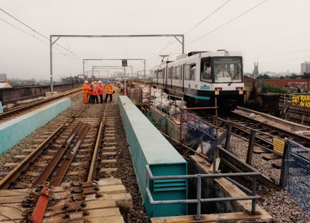
View towards Manchester, showing Metrolink bridge and repositioned Altrincham track. Photo by Altram, August 1998. |
Metrolink Cornbrook layout
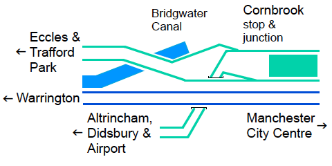
Showing the non–conflicting junction with Altrincham line going under Eccles outbound line and main line railway. |
Cornbrook Road railway bridge had a three track western/northern span on which track positions could not be changed. This was replaced, before Metrolink opened, by a new half–through steel box girder deck bridge to carry both Altrincham line tracks.
During construction work for the Eccles line the eastern/southern two track span was modified and strengthened. The outbound track was then moved from the new half–through steel box girder deck bridge; as shown in the photo.
Altram were the company who had the concession to design, build, operate and maintain the extension to Eccles via Salford Quays, and to operate the Metrolink line from Bury to Altrincham, via city centre Manchester.
Cornbrook stop was used as an interchange between Altrincham and Eccles lines from 6 December 1999. Following improvements at street level, the stop opened fully on 3 September 2005.
Just south of Cornbrook Road British Rail (BR) built the underpass which segregates Metrolink from the Manchester–Warrington–Liverpool line. It takes Metrolink from the CLC viaduct onto the MSJA alignment a little south of the former railway Cornbrook Junction.
The eastern abutment of the future Eccles line bridge over the Bridgewater Canal was built with the underpass. On this isolated small site it would have been difficult and very expensive to do it later.
Trafford Bar junction and stop
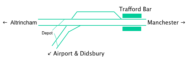
Showing the depot connections, Airport & Didsbury line burrowing junction and stop |
The line continues to Trafford Bar stop (Old Trafford in MSJ&AR to British Rail days); this name derives from Chester Road having had a toll bar here at one time. As with other stops a minimum of alterations were done for the 1992 conversion to Metrolink.
Then in 2001 a new concrete stairway was provided between Elsinore Road and the Altrincham bound platform. In 2004 the Manchester bound platform pedestrian ramp had its slope reduced and new double hand rails were installed. A new concrete stairway from the platform to the upper end of the ramp was opened. The former booking office lobby was taken out of use and the old railway stairs to the platforms have been removed.
A burrowing junction with the Didsbury inbound line passing under the Altrincham line was built for Metrolink. This is possible with Light Rail technology. The low level CLC route, which passed under the Altrincham line and joined the Liverpool via Warrington line plus Cornbrook carriage sidings have been redeveloped out of existence.
The line to Didsbury uses the former Midland and CLC route which Manchester Corporation/City Council purchased when the line closed. East Didsbury stop is east of Kingsway and near the Manchester City/Stockport MBC boundary.
The 14.5 km Airport line diverges from the Didsbury line at a junction just to the south of St. Werburgh’s Road stop. It runs on a mostly segregated alignment with short sections of street–running. Most road crossings have tram signals and traffic lights for road vehicles. South of Altrincham Road the route mainly uses the wide grass verges alongside roads. Most stops have two side platforms.
The depot is between the Altrincham and Airport/Didsbury lines with Ayres Road as the southern boundary. A portion of Elsinore Road within the depot site and the bridge which carried it over the CLC line were removed. There are tracks, a washing plant, workshop and offices. Previously based at Queens Road depot, the control room — known as the Network Management Centre — is now here with the Customer Services team. Major work on trams is done at Queens Road Deopt.
Old Trafford stop
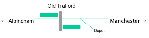
Showing the staggered platforms, track level pedestrian crossing and depot connection |
Known as Warwick Road in MSJ&AR to British Rail days, this stop was upgraded in 2009. The Altrincham bound platform was extended to 120 metres. A new track level pedestrian crossing replaced the old underpass. Alongside Lancashire County Cricket Ground, a new 120 metre long platform replaced the old Manchester bound one.
Now that the TMS line of sight tram operating system is in use, there can be two double trams in each platform.
In 2018 the TMS was altered to enable moves from the outbound line and the depot to the inbound platform.
A new gated queuing system has been provided for the whole stop. It will be used at the busiest times — cricket or football match days and during major events. Manchester United’s stadium is about half a mile away. On average 2,000 passenger journeys are made from or to the stop each day. An extra 7,500 are made when Manchester United have a home game. A simpler arrangement will operate on other days.
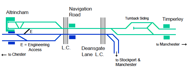
The Manchester to Chester via Northwich trains, which shared the Altrincham line with the British Rail electric trains, were diverted to run to and from Manchester via Stockport. This enabled the electrified line to be converted for use by Metrolink.
In July 1991 British Rail (BR) remodelled and resignalled the Altrincham area, totally separating the tracks to be used by trams and main line trains.
Just south of Timperley station there is a turn back siding facing Manchester between inbound and outbound lines. This enables trams to reverse at Timperley, should some difficulty prevent running over the Network Rail line. The Metrolink control boundary is just north of the double to single Metrolink junction.
From Deansgate Junction (DJ) (Altrincham), which is named after Deansgate Lane and has a level crossing, to just south of Navigation Road level crossing there are only two tracks. Widening the formation would have been prohibitively expensive so there are two bidirectional lines, one for Metrolink and the other for main line trains. Just north of DJ level crossing the Stockport and Manchester line comes in from the east and becomes a single line.
At Navigation Road stop Metrolink uses the western, formerly Manchester bound, platform while main line trains use the eastern platform.
Using the four track formation width between Navigation Road level crossing and Altrincham the layout, from west to east is now Metrolink inbound, Metrolink outbound, main line to Stockport and main line from Stockport.
At Altrincham station, Metrolink uses the terminal platforms from which the BR electric trains ran. In 2009 platform 1 was shortened slightly and a level access route to platforms 2 and 3 built. The main lines from Chester via Northwich use the through platforms 3 and 4.
This page is a very brief summary about Metrolink on the MSJ&AR line. Your webmaster has an extensive set of Manchester Metrolink pages; last updated on 10 December 2019; in the archive section of the Light Rail Transit Association web site, which has had a wholesale reconstruction!
Altrincham Electric Railway Preservation Society
Registered Charity (No. 1093098)
© April 2020